


LATERA
. Credit: Euromedia for Saint Francis’ Way


LA TUSCIA VITERBESE,
LATERA
AND
LAKE BOLSENA


La Casa Etruria Artist Residency has two locations. One is in the small medieval village of Latera, the second one is in the countryside near Sorano, Tuscany.
Latera is situated in the north of Lazio, more precisely in the Tuscia area of the province of Viterbo -also referred to as 'La Tuscia Viterbese' Even more precise: in the area referred to as 'Alta Tuscia'.
Tuscia Viterbese is a relatively unknown region in the north of Lazio, near the borders with Umbria and Tuscany. It is bordered by the sea to the west, including the coastal town of Tarquinia (the former Etruscan capital), and to the east by Bomarzo and Orte. The northernmost town that is still part of Tuscia is Acquapendente. On the southern border are Sutri (with a beautiful Roman amphitheater) and Nepi (of the famous spring water). The beating heart of Tuscia Viterbese is the city of Viterbo, which is a 40 minute drive from Latera.
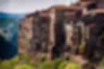
Latera is a small village surrounded by chestnut woods and very close to Lake Bolsena and the border with southern Tuscany. It is situated 508 meters above sea level, in the north of the Tuscia region and very close to the beautiful southern Tuscan villages of Sorano and Pitigliano (18 minutes by car)of which we come to speak later on. It is also close to Umbria, with its beautiful medieval town of Orvieto, famous for its beautiful cathedral and hilltop setting, and just a 40 minutes drive from Latera. And it is about 140 km northwest of Rome. In Orvieto there are trains to both Rome and Florence.
Latera is perched on a hill on the edge of a valley of volcanic origin -named 'Caldera di Latera'- and surrounded by thick chestnut woods that seem to hide it from the eyes of travellers. It is just a stone's throw from Lake Bolsena and Lake Mezzano. The historic center has a typically medieval structure and is surrounded and protected by thick chestnut woods that tend to hide it. In fact, 'Latera' literally means "Latere" which translated means "to hide, conceal". The choice of the toponym refers to the geographical location of the village, which is hidden by vegetation.
Latera's historic center is entered through a rosy stone gate that in the past also featured a drawbridge. Passing through the gateway, one finds oneself in a place lost in time, with narrow cobblestone alleys, stairways, dark underpasses and stone houses, often embellished with the typical profferli, elements typical of medieval architecture in the villages of the Viterbo area, external stairways that allowed access to the upper floor. Inside the historic center it is possible to admire a series of interesting buildings and churches, the history and traditions of this village.
What to see in Latera
-
Palazzo Farnese: it stands on the ruins of an ancient Lombard fortification and bears witness to the turbulent history of the town
-
La Caldera di Latera: a volcanic formation of great geological importance, which is home to rather rare and unusual species of flora and fauna
-
Lake Mezzano: a nearby lake offering natural beauty and opportunities for outdoor activities
-
Events and Festivals: Latera is famous for its culinary traditions, such as the pinching festival, the Latera chestnut festival, and the feast of the Madonna with the chestnut festival. These events celebrate the typical dishes of Latera's peasant cuisine and offer an authentic experience of local culture.
-
Earth Museum (Museo della Terra)


LATERA

Latera is a village nestled inside the 'Caldera', where underground geothermal outpourings are still found.
The locality has very ancient historical origins as evidenced by finds dating back as far as 5000 BC. The village, as we know it today, dates back to medieval times. Latera's history is inextricably linked to the Farnese family who were responsible for the construction of its most important buildings. First of all the Farnese Palace, symbol of the village's strong bond with the Farnese papal family. Close to the Palace is Piazza della Rocca which offers a pleasant view of the eastern part of the village and a view of the green woods that surround the town. The structure of the Palace is unique with the other valuable building which is the Church of San Clemente with a sober and at the same time elegant appearance.
Furthermore, to testify to the presence of the Farnese family there are still some fountains that adorn the town such as the Fontana Ducale, better known as the Fontana del Ponte, dating back to 1648, and the Fontana del Piscero which still shows the symbolic Farnese lily dating back to 1576.
Then there are other churches of particular interest that deserve a visit, such as the small and pretty church of San Giuseppe located at the end of the main street of the town, Corso Vittorio Emanuele III, or the churches of San Sebastiano, San Rocco and the Chiesa of the Madonna della Cava just outside the small village. The latter, the furthest from the town and also the one dearest to the Laterese, represents the symbol of the miracle which, according to the inhabitants of Latera, took place during the Second World War. In 1944 Latera was bombed but the town was not hit by the bombs which instead all aimed at the church of the Madonna della Cava, destroying it and leaving only the apse intact. Even today, the Lateresi remember this episode every year, thank the Madonna for having saved them and start a torchlight procession that heads from the town towards the church. Another place of interest that is worth a visit is the Earth Museum where objects from daily life and from the peasant and popular culture of the past are preserved.
One of the typical trees of the Laterese landscape is the chestnut and the food that best represents this area is undoubtedly the chestnut. The Latera Chestnut Festival takes place during the last two weekends of October and represents a moment of great conviviality, an opportunity to discover the area and its food and wine products.


Just a few kilometres from Latera you will find the beautiful LAKE BOLSENA. It is not just a lake but the apotheosis of nature that offers breathtaking scenery, such as the one you can admire from La Rocca dei Papi (popes’ stronghold) in Montefiascone. It all started hundreds of thousands of years ago. A volcanic explosion threw out lapilli, pozzolana, and lava, emptying the underlying area. The surface crust sank forming a caldera. In the course of tens of thousands of years, the rain filled up this huge crater creating Lake Bolsena. Volcanic activity continued and other explosions inside the lake led to the formation of two marvelous islands: Martana and Bisentina.
Nowadays, Lake Bolsena, with its 13.5 km (8.4 miles) in length and 12 km (7.5 miles) in diameter, is the largest basin of volcanic origin in Europe, and one of the main travel destinations for nature lovers.
Surrounded for the most part by the Volsini mountains, Lake Bolsena has a picturesque and wild aspect that attracts thousands of people every year. The history of this reservoir is closely connected to the populations who inhabited it, in fact the territory that surrounds its perimeter which reaches 43 km in extension is rich in suggestive villages and many archaeological historical sites that testify to its antiquity.
Bolsena Lake is part of the Vulsino volcanic system which was originally characterized by seven craters. Following a violent explosion, the volcano collapsed on itself thus creating a caldera which over the centuries has covered itself with water, forming the basin. In the Latera basin and along the rugged coast of the Bisentina island there are still traces of the original volcanic craters.
The Lake Bolsena area is a place rich in nature, art and ancient history. There are nine villages ('borgi', including Latera) that make up the surroundings of the volcanic basin and each of them hides interesting places to visit. In the wider area of the lake you will find very interesting towns such as Acquapendente, Civita di Bagnoregio, Orvieto, Tuscania, and Pitigliano. And villages like Farnese, Piansano, Cellere, Vitorchiano, Bomarzo and Celleno.


SORANO AND PITIGLIANO
CITTÀ DEL TUFO
CITIES OF TUFF

SORANO
In the southernmost hills of Tuscany it looks as if a sculptor has carved a village out of the tufa rocks. Among the lush greenery rises Sorano, a historic village rich in archaeological, architectural and natural treasures. The picturesque 'rock sculpture' is also called the 'Matera of Tuscany' and is located in the Maremma Toscana. It is amazing how well the historic center has been preserved over the centuries.
Situated on a tuff spur, the village overlooks a green valley through which the Lente river flows. In some places the village is almost indistinguishable from the hill and Sorano seems to have actually been dug from the tuff. Surrounded by olive trees, cypresses and the sound of the flowing river, it is a place where the soul of Sorano has lived on for centuries.
Historical center
In the Middle Ages, Sorano took its current form and it was the powerful Aldobrandeschi family that ruled over the area. This was followed by the Orsini family until Siena took possession of it in the 15th century and had to hand it over to the Medici family from Florence a century and a half later.


The citadel is located 379 meters above sea level and appears to consist of several levels connected by a labyrinth of narrow streets. The 'centro storico' is an intertwining of arcades, courtyards, arches, portals, external stairs and loggias. The tuff village is dominated by the Orsini fortress, which towers high above the churches and bell towers. The complex is an admirable example of Renaissance military architecture with two imposing bastions.
A walk through Sorano consists of traversing a maze of narrow streets. Among the simple but beautiful old houses, some buildings of great value stand out. The Church of San Nicola is one of them and is located in the heart of the center in an elevated position. Unfortunately, not much remains of the original construction, as the sanctuary was extensively renovated in the 16th century. However, at the back you can still admire the last traces of the Romanesque period. The Chapel of the Madonna del Buonconsiglio stands along Via del Cimitorio.
The old Jewish ghetto, founded in the 17th century by the Medici family, is special. The lively neighborhood was abandoned by the Jewish community at the beginning of the 20th century and fell into disrepair. In the 1990's the ghetto was returned to its original appearance and is an attraction in itself.


The mystery of the 'Vie Cave' (hollow roads)
The tuff area was inhabited by the Etruscans and, according to historians, the history of Sorano begins in this period. A legacy of this ancient civilization is the remarkable Vie Cave, a network of tunnel-like passages carved into the tuff. They connect the villages of Pitigliano, Sovana, and Sorano, as well as several important sites of Etruscan society, such as rivers, prayer sites, and a necropolis. In many places within the road network you can find Christian symbols on the walls and shrines next to the paths, which served as protection against spirits and other bad influences at the time. However, the question remains why the Etruscans built this vie cave and especially why it had to be dug so deeply.
It appears to be an impressive road network connecting several places of great importance in Etruscan society. However, the fact that this network is completely buried suggests that these roads were also used for other purposes besides simple transport. In addition, some of the vie cave are barely wide enough for a human or animal to pass through, let alone a large transport.
Nowadays you can enjoy wonderful walks there and it attracts many archeology enthusiasts. The most important walk is that of San Rocco. Maps can be picked up at the Vie Cave Archaeological Park or in Sorano tourist office.
VITOZZA
LA CITTÀ PERDUTA
THE LOST CITY

A short drive away from Latera, near the village of San Quirico, in the municipality of Sorano, you will find Vitozza, a cave settlement which was inhabited from Etruscan times until the end of the 18th century. It is part of the 'Città del Tufo Archaeological Park'. The earliest evidence of the settlement dates back to the 11th century, when numerous castles were built throughout the area. Vitozza must have been part of a large feud comprising fifteen castles, among which Sorano, Pitigliano, Farnese and Mezzano are mentioned. The feud must have been of considerable strategic importance as through the fortifications it was possible to control the natural routes to the sea.
The ancient city of Vitozza was built around a castle built by the Aldobrandeschi family within a cave settlement which was most likely already inhabited during Etruscan and Roman times.In the Middle Ages, Vitozza had a fortified castle, at least two fortresses, and places of worship including a major and two minor churches, in addition to the cave settlement.
The cave settlement of Vitozza is the largest and most important of central Italy. It includes over two hundred caves excavated from the local tuff stone and used since the earliest times for dwellings, stables and outbuildings. The caves used for human habitation extend along a path through the woods overlooking the valley of the river Lente. Some are quite close to each other, while others tend to be more isolated.
The spaces, now abandoned, still retain traces of their use; in fact, there are cisterns for collecting rainwater, wells for waste, niches, holes and curbs for the placement of bedding, stone tanks. According to their use, the caves have been divided into three types: caves for mixed use, that is, composed of living quarters and stables; stables, in which there are mangers, troughs, pens; caves for residential use, found mainly on the southwestern slope, which is more sheltered and better exposed to the sun, characterized by pots for grain, wells for water collection, chimneys.
Particularly striking are some rooms marked by the presence of numerous small niches carved into the walls, the so-called columbaria. For a long time, they were considered Roman funerary monuments; recently, thanks to the detailed descriptions of ancient scholars, the prevailing hypothesis is that they are environments excavated in medieval times for the breeding of doves and pigeons.
For those who are animated by the spirit of adventure, past the area called San Angiolino, it is possible to venture into the forest and reach the springs of the Lente River. The exceptionally beautiful natural environment, the bridges and tunnels of the old 19th century aqueduct, the waterfall and the glass well make the visit truly exciting and challenging.
From the springs, through a marked path of about 5 km, it is possible to walk to Sorano.


PITIGLIANO
Pitigliano, la magica città del tufo, is one of the most beautiful villages in Tuscany, and only a 19 minute drive away from Latera. The originally Etruscan town is beautifully situated on a tuff rock in the Tuscan Maremma. If you approach Pitigliano from the south you will have an unparalleled view of the city. The Sanctuary of the Madonna delle Grazie is a nice place to stop and admire the impressive beauty of Pitigliano. Like Sorano the town is built from volcanic tuff rock, carved from the cliff on which Pitigliano perches imposingly, overlooking verdant canyons and Monte Amiata on the horizon. A short distance from its sister towns Sovana and Sorano, Pitigliano sits at the intersection of two Italian cultures–Jewish and Catholic–and two borders–Tuscany and Lazio.
A brief history of Pitigliano
Pitigliano is the city of the Orsini, a papal family from Rome who governed Pitigliano from 1293. Until then, the town belonged to the Aldobrandeschi family, an influential family that controlled the entire southern Tuscany. Through a marriage with the Orsinis, Pitigliano came under Roman influence. In 1293, Anastasia, daughter of Countess Margherita Aldobrandeschi, married Romano Orsini. The county of Sovana to which Pitigliano belonged became the dowry, and the seat of the county was transferred to Pitigliano. The Orsini coat of arms adorns the gateway to the historic center of Pitigliano.
The Orsinis ruled the county of Pitigliano for centuries and defended it against constant attempts at subjugation, first by Siena and Orvieto, later also by the Medici of Florence.
It was not until 1574 that Niccolò IV Orsini ceded Pitigliano to the de'Medici family and in 1604 Pitigliano was annexed by the Grand Duchy of Tuscany. However, the Medici had little interest in the fate of the city, which quickly fell into decline. It was not until 1737, under the Grand Duchy of Lorena, that Pitigliano experienced a slow economic and cultural recovery.
Etruscan period in Pitigliano
The origins of Pitigliano are very ancient, as evidenced by the archaeological findings in the oldest part of the Tuscan village. Pitigliano, like most of the territory of the Fiora River valley, had prehistoric and protohistoric settlements mainly linked to the extraction and processing of metals and to the defensive security guaranteed by the tufa cliffs.
Particularly interesting is the discovery, in the 1980s, of a necropolis dating back to the Cività di Rinaldone – a funerary cultural phenomenon widespread in Tuscany, in central-northern Lazio and in the Marche region. Dating back to the Eneolithic period, between the middle of the fourth millennium and the first part of the third millennium BC, it is identified by its oven or cave tombs found in the archaeological site of Poggialti-Vallelunga.
Another archaeological area, north of Pitigliano, houses the remains of an ancient village that embraces a temporal arch that goes from the Middle Bronze Age – 17th century BC – to the Final Bronze – 10th century BC.
The wealth of ancient settlements and necropolis indicate Pitigliano was, in effect, one of the main centres during the Villanovan period in the Valle del Fiora, between the 12th and 10th centuries BC. The area of Pitigliano was slowly abandoned in favour of the coastal town of Vulci in later centuries.
From the 8th century BC however, the Valle del Fiora had a strong rebirth, it is in this period in fact that some of the most important Etruscan centres were born, in particular those of Pitigliano, Sovana, Poggio Buco and Castro, thanks in particular to populations coming from the same Vulci and nearby Tiberina area.
After Poggio Buco was abandoned, Pitigliano became the main Etruscan city of the Valle del Fiora, thanks in particular to its strategic position – it was born on an impressive tufaceous rock – and to the construction, in the 6th century BC of its walls, which surrounded the built-up area between the Porta di Sovana – also known as Porta di Sotto – and one of the oldest neighbourhoods of Pitigliano, that of Fratta.
The Etruscans carved burial walls into the rock walls, the so-called colombaria – dovecotes – with small cages for the ashes of the deceased. These burial vaults are still in use, but now mainly wine is stored. The tufa creates optimal conditions for storing and maturing wine. The labyrinth of corridors, wine cellars and underground warehouses that have been built underground is almost as large as the village that you can see with the naked eye..


Pitigliano, also known as 'Little Jerusalem'
The Jewish Quarter is a significant part of Pitigliano's history. The link between Pitigliano and its Jewish culture is extremely old: the first community to find refuge in this tufa-carved town dates back to the end of the 16th century. In 1555, the Jewish community fled Rome and its Catholic authority, seeking refuge in Tuscany. Many came to Pitigliano when welcomed by the locals, who did not support the Pope. One of the first buildings they built after settling in the community was the synagogue, which dates from 1598. The beginning of peaceful coexistence between the Christian majority and the Jewish minority until the 19th century.
Unfortunately, the original structure was partly destroyed during the Second World War, but was later expertly restored and can be visited today (except on Saturdays and Jewish holidays). On the walls, decorated with stuccos and decorations, are numerous commemorative inscriptions in Hebrew. The Tevà is at its centre, while, in the background, you can see the holy ark in wood, the Aròn. On the upper level, behind a richly inlaid balustrade, are the benches of the women's gallery. The upper part of the synagogue is reserved for women.
The community in Pitigliano grew to an extent that it became known as the “Little Jerusalem”, a nickname given to it by the city of Livorno, the other important Jewish centre in Tuscany. After the unification of Italy in 1861, the Jews were emancipated and many left Pitigliano in favour of the bigger cities.
When the racial laws hit Europe in 1938, the number of Jews living in Pitigliano decreased even more, until only a few families were left. During the war, those remaining got help from the locals; Christians that had lived side by side with them in peace for centuries helped them to hide in the countryside and escape deportation.
Today just a few Jews live in Pitigliano, and the ancient ghetto has became a museum, an important witness of the turbulent history of this people, and a precious piece of the town’s heritage. At the entrance men are asked to cover their heads, and offered a kippah. Women need to be decently dressed.
In the Jewish quarter you will find the museum of Hebraic culture. There you will take a voyage into the past, experiencing a bit of everyday life in the ancient Jewish community of Pitigliano. You will enter a labyrinth of evocative dens dug into the tuff: the ancient furnace that served the Community until 1939, where the unleavened azzimo bread was baked, the Kosher kitchen where the wine was produced, the butchery where animals were slaughtered according to kashrut and the ancient miqvè in which both men and women took ritual baths. In order to bring you closer to Hebrew culture, the museum was conceived as an educational itinerary: you’ll find images, objects and lots of subtitles explaining Jewish traditions and habits.
In addition, you’ll be able to admire one of the five sinagogues of Tuscany, built in 1598 by Leon of Sabato.
The museum is open all year, from Sundays through Fridays. See the Pitigliano.org website for more details. The address is Vicolo Marghera, Traversa Via Zuccarelli 58017 Pitigliano (GR)
Phone: +39 0564 614230.


BOLSENA
CITY OF HISTORY, ART AND CULTURE
Visiting Bolsena is like taking a journey back in time, accompanied by the surprising view of the largest volcanic lake in Europe. The town to which Lago di Bolsena owes its name, with just over four thousand inhabitants, is a relatively small town and is located in northern Tuscia, just 17 km east of Latera. The town fascinates with its history and natural beauty. Rising on a hill on the slopes of the Volsini Mountains, it offers a panoramic view of the lake.
The town is historically associated with agriculture and fishing. Nowadays, in a long street that runs from west to east, you will find many small shops from local entrepreneurs, who sell authentic products. At the end of this long street is the Rocca Monaldeschi, a beautiful castle from the fourteenth century. In the castle you will find the Territorial Museum of Lake Bolsena (https://www.simulabo.it/i-musei-del-sistema/museo-territoriale-del-lago-di-bolsena/). Here you can discover the history of the lake and the city of Bolsena through archaeological finds. An entrance ticket also gives access to the castle's roof terrace, where you can enjoy beautiful views.

THE ARCHEOLIGAL AREA OF VOLSINII
IN POGGIO MOSCINI
The Etruscan city of Velzna, identifiable with present-day Orvieto , was destroyed by the Romans in 264 BC . and refounded on the north-eastern shores of the nearby lake, where the Roman center of Volsinii developed , the ancestor of today's Bolsena. Urbanization took off about a century after the foundation of the city, coinciding with the opening of the Via Cassia. Volsini in fact assumed the strategic role of controlling this road.
It was the excavations of the French School of Rome at Poggio Moscini that brought to light the remains of the Roman city today, visible in the archaeological area of Poggio Moscini. This is the vast forum square (about 57 m wide), bordered to the south by an imposing basilica divided into three naves and with the magistrate's seat on the short side (27 x 57 m), which was later transformed into a church . In the forum area there were a system of cisterns dating back to the 3rd century. to. C., interpreted as a vivarium for breeding lake fish ; shops (painting fragments of a taberna of the second Pompeian style are in the Territorial Museum of Lake Bolsena ), a warehouse, a richly decorated public latrine ( forica ) (see the large fresco attributable to the third Pompeian style of the Augustan age preserved in the Museum Territorial of Lake Bolsena ), all environments part of an island . The access to the basilica consisted of three monumental porticoes. A tecta (i.e. covered) street leads from the forum area to the residential area, where two large domus have been brought to light.
The House of the Nymphaeum
On an area to the NW of a small temple on which a nymphaeum would later be built, a domus was built which in the 40-30s BC. takes on the appearance of a luxurious residence; the two sides of the nymphaeum are characterized by niches. In the Territorial Museum of Lake Bolsena, an oscillum and small sculptures are preserved, including a cupid and a fragment of a statuette of Venus from excavations in this area.
The House of Paintings
Below the triclinium and peristyle of the house, known as an atrium house and built from the 2nd century. to. C., a group of terracottas with Dionysian subjects emerged among which the Throne of the Panthers stands out : (preserved in the Territorial Museum of Lake Bolsena ), it was therefore hypothesized that a sanctuary dedicated to Dionysus was located here, destroyed following the repression of the Bacchanalia voted by the Roman Senate in 186 BC. C. Two of the most important cubiculas of the house are decorated with paintings dating back to the 3rd century. d. C. preserved for a height of approximately four metres, i.e. almost equal to the height of the original ceiling.
The city was equipped with:
- a theater (not located) as can be deduced from a dedicatory inscription preserved in the Lapidarium of the Territorial Museum of Lake Bolsena ;
- of a library ;
- of a place of worship for Silvano on the Mercatello hill;
- of a large amphitheater on the Mercatello hill not far from the Via Cassia of which the monumental remains are preserved;
- of thermal facilities of which a cryptoporticus, a large rectangular room and a large cistern remain.
The city was gradually abandoned during the 5th century. AD although evident destructions were found as early as the end of the 3rd century. AD The citizens preferred to occupy the nearby cliff on which today's Castle district stands, easily defensible and the first urban nucleus of Bolsena .
Numerous finds and frescoes from the Etruscan-Roman city of Volsinii are exhibited in the Territorial Museum of Lake Bolsena.


CIVITA DI BAGNOREGIO
Visiting the territory of Bagnoregio and the surrounding area, known as the Valle dei Calanchi, is one of the most exciting experiences that can be had in Central Italy. Every year more than a million people from all over the world come here to see an ancient beauty up close, which defies time and the erosion of the tuff spur on which it is positioned.
On top of a steep cliff standing out from the surrounding countryside, lies the small town of Civita di Bagnoregio, one of the oldest and most fascinating villages in the Tuscia area of Lazio. It is often called "the dying town", although more recently people have started to refer to it as fighting to live... What this little town is fighting against is the threat of erosion, as its walls are slowly crumbling down.
Civita is one of the oldest and most fascinating villages in the Tuscia area of Lazio. A hamlet of the municipality of Bagnoregio, from which it is just one kilometer away, it rises on the border with Umbria, halfway between Lake Bolsena to the west and the Tiber Valley to the east.
It is in a dominant position on a tuff hill squeezed between two valleys where the Rio Chiaro and the Rio Torbido flow, in a geographical area of great naturalistic impact and uniqueness known as the Valle dei Calanchi. Certainly one of the most extraordinary landscapes in Italy. It is precisely this position that has marked the history and threatened the very survival of the small and fascinating hamlet.
On foggy days, Civita appears in its ancient medieval appearance, like the mirage of an island floating in the void or lying on a cloud, suspended in time and space. A scenario that does not lose its charm when the enchantment is revealed and the long and unique road that from the south-western side connects the "mainland" to the ancient village is discovered.
The Calanchi Valley
The Calanchi Valley is an area that is morphologically and geologically as interesting as it is fragile: the territory is made up of a first band of clayey formation, dating back to a few hundred thousand years ago and of marine origin, to which a second sediment of lava and tuff material was then added. This combination has translated into a "dynamic" territory, that is, highly subject to the occurrence of an intense and relatively fast modelling proces, so much so that the gullies are a real living landscape, in continuous transformation. The erosion activity due to wind, water, rain, as well as seismic events that have affected the area over the years has individually shaped the entire landscape, making it unique in its kind. All around you can admire long and thin clay crests with a jagged and steep shape, formed following landslides that have left space for bare rocky slopes of great charm. An astonishing context and, at the same time, absolutely precarious and unstable. In these valleys, more than anywhere else, human architecture tends to become camouflaged, in an attempt to integrate with an environment that by its nature threatens its existence.
The Dying City
The town of Civita dates back to the Etruscan civilization, about 2500 years ago. It was most likely built on top of a hill for military reasons, since the 200 m of difference in height would provide perfect panoramic views. The city’s major development took place during the Middle Ages, and its well-preserved medieval character is one of the features that makes this city so magnificent nowadays. However, in 1695, a terrible earthquake demolished most of Civita by triggering a major landslide below, and forced people to move to the neighbouring village of Bagnoregio. This was not the only landslide that threatened the city. For centuries, Civita has been fighting against the natural degradation of the cliff, with recurring landslides slowly taking down the edges of the plateau, causing some of the medieval buildings to collapse and plummet into the ravine.
The geology of the plateau explains why this town is so susceptible to landslides (Figure 1, Delmonaco et al., 2004). The top of the plateau consists of a 20 m thick layer of consolidated rock formed from volcanic ash (ignimbrite), also known as tuff. The tuff was deposited by pyroclastic flows (rapid currents of volcanic debris and hot gas) related to the neighbouring Vulsini volcanic complex. This massive tuff layer overlies a more stratified section of pyroclastic deposits, roughly 70 m in thickness. These quaternary volcanic deposits lie above a bedrock of Plio-Pleistocene clay, which can be found all over the valley. This succession forms a classic setting for landslides. In the fragile clay deposits, slope instability is represented by mud flows and debris flows, while the upper, volcanic part of the plateau suffers from rock-falls, toppling and block-slides as it becomes unstable. Landslides can be dated back to 1373 AD, with 150 landslides documented by scientists who investigated the local geomorphology (Margottini and Di Buduo, 2016).

Geological profile of the area.
Credit: Giuseppe Delmonaco
Due to the continuous progressive landslides Civita has undergone over the years a progressive thinning of the land on which it stands. Access to the village therefore is only permitted on foot across a long reinforced concrete bridge -built in 1963 to replace the precarious paths that existed at the time- for the few inhabitants that still remain (about ten) and the numerous people who visit it. This panoramic walkway is the first magical experience that must be faced to reach the small urban fortress of Civita. An experience that offers countless perspectives on the landscape and the village itself, and which leaves the visitor with an unexpected sense of wonder.

1 Year Warranty
Only the Best
This is your Feature description. Write a short blurb explaining what the feature is and why it matters for visitors, customers or clients. Don’t be afraid to toot your own horn! Take this opportunity to emphasize the important benefits or key advantages.